13 places to walk your dog off lead in and around Urmston. (In no particular order.)
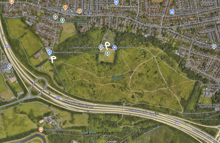
Stretford Meadows are a continuation of Urmston Meadows separated by the M60. There is a pedestrian bridge over the motorway at the south end and, I seem to remember, a subway at the west end just south of Loretto Road.
It’s a pleasant walk when it’s dry but gets quite muddy when wet. It would take around 40 minutes to walk the perimeter.
There’s access to Riverbank Coffee, the river and Sale Waterpark over the bridge.
If accessing via Lesley Road be aware that you have to climb through a large hole in the gate at the end of the track!
Stretford Meadows
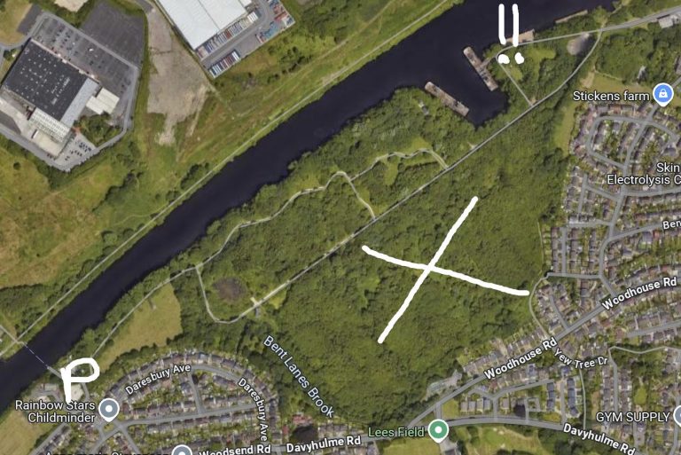
Opened, believe it or not, on the millennium, this green space is quite small and normally quiet.
Parking is off Daresbury Avenue (P) and the only paths are visible on the map. There is steep drop into the canal at the spot marked !! so care should be taken. There are also a couple of ponds which certain dogs (labradors especially) will find tempting.
Unfortunately there is no access to Barton Locks or the sewage works despite the map showing a path. Also there is no access to the wooded area marked by X.
Finally, it closes early in winter so be sure to read the notices to avoid being locked in!!
Davyhulme Millennium Nature Reserve
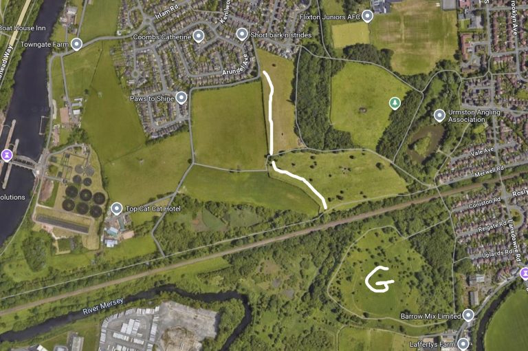
In between the Mile Road and Wellacre lies the “country park”.
It’s in 2 parts, the hill and the fields with the railway separating the two.
It’s away from traffic with the only dangers being horses and angry fishermen from Dutton’s pond who, quite reasonably, take exception to 40kg labradors jumping in the pond and eating their bait.
The white line I’ve drawn is a public footpath running through 2 horse fields. I’ve only ever seen one of the fields populated with horses, not both.
The imaginatively named Green Hill is marked by G on the map.
Finally, it’s kind of possible to get to Irlam Locks by following the path running parallel and to the north of the railway and then along the canal. Take bandages, wire cutters and life buoys if you attempt this.
Wellacre Country Park and The Green Hill
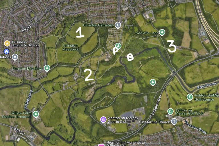
Urmston meadows is massive. I personally think of it as 3 different parts, all interconnected.
Area 1 is accessible from Riverside Drive and Cedar Drive. it has access to the beach (B) near the cemetery.
Area 2 can be accessed via Eeasbrook off Queens Road where you can park at P and Cob Kiln Lane opposite The Lord Nelson pub.
Area 3 can be accessed again from Cob Kiln Lane, Lime Tree Close and Torbay Road.
There’s a lot to discover on the meadows, too much to write about here. I’ve been exploring it for 50 years and still don’t know every route and path!
Urmston Meadows
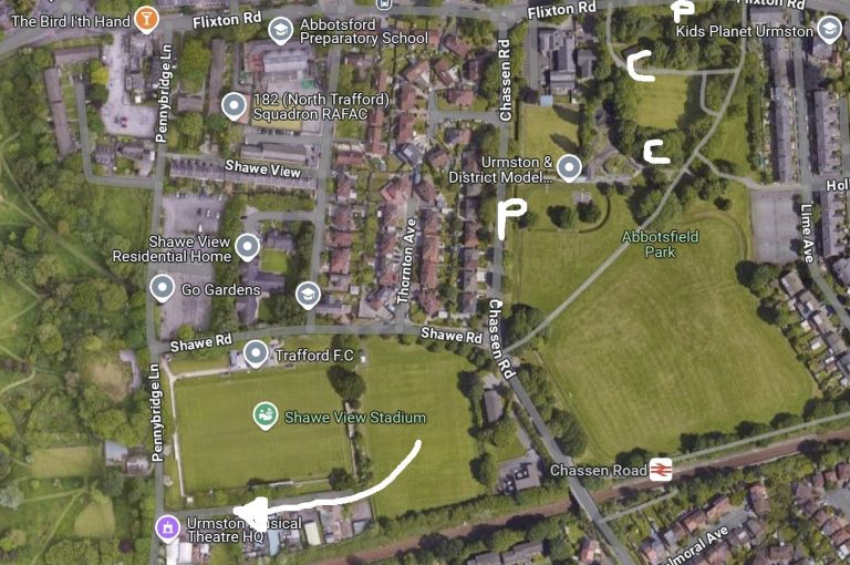
Another small park which is famous for once hosting a Beatles concert. You can stretch a walk around the perimeter to 30 minutes if you include Trafford FC’s training ground situated across Chassen Road next to the stadium. There’s also an exit on the other side of the training ground to the disused William Wroe golf courses.
On Sundays there’s a miniature railway for the children next to the playground. There’s a cafe in the bowling green hut and sometimes a visiting coffee shop. Marked by C on the map.
People park along Chassen Road and Flixton Road, marked by P on the map. It can get very busy at weekends.
Abbotsfield Park aka Chassen Park
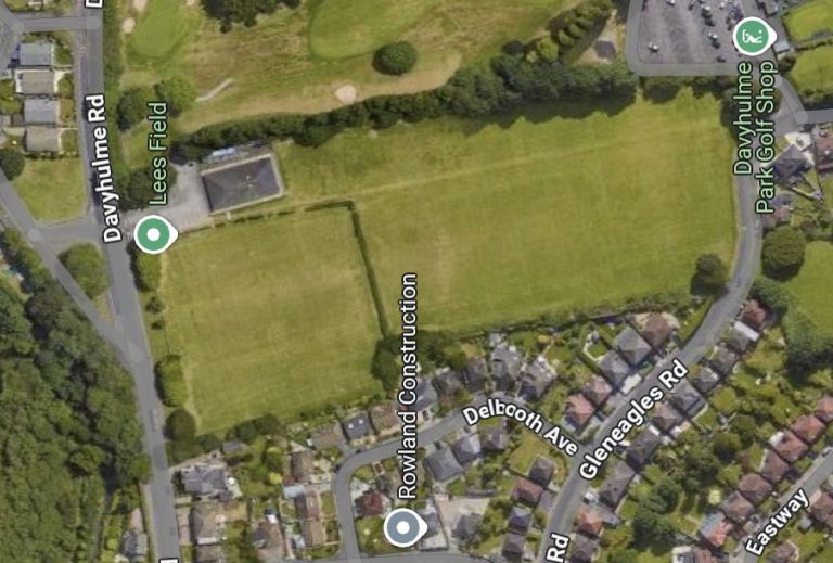
Nestled between Davyhulme Road and Gleneagles Road we find Lees Field which is probably the smallest area featured in this guide.
I think the field is owned by Urmston Meadowside football club and they allow the public to use it. There is a public footpath running through it as well.
It only takes 15 minutes to walk around the field. It’s open to Gleneagles Road and has two entrances on Davyhulme Road so not the safest of walks for wandering dogs.
Lees Field
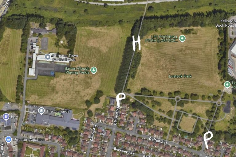
This is a favourite of mine for walking a small group of dogs. It’s safe, a good size and has shaded paths for when it’s warm and sunny.
It takes 30 minutes to walk the perimeter of both fields. There’s a hole in the fence marked by H on the map and a gate at the top of Old Hall Road between the 2 fields.
The park can be found at the ends of Old Hall Road and Curzon Road which are both off Barton Road opposite Lostock School. You can park at the bottom of these roads marked by P on the map. Please be considerate of residents.
Lostock Park and Barton Clough playing fields.
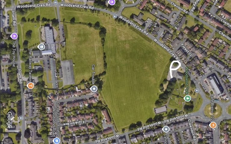
This ‘park’ pushes the boundaries of off lead safety. There is no fence so most walkers tend to stick to the middle of the field.
You can walk the perimeter of the field in 15 minutes.
Parking is available at the building close to the playground off Woodsend Crescent Road, marked by a P on the map.
Woodsend Field
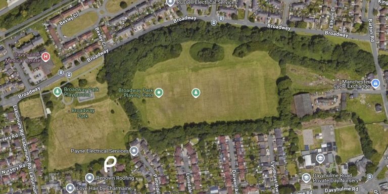
Looks bigger here than it is and will only take 20 minutes to walk around.
There is very limited parking at the community centre accessed from Davyhulme Road and marked with a P on the map. Most people park on Broadway near the playground.
You can walk in the wooded area to the north of the main field but it gets muddy in the winter, probably because it’s where the brook used to be before being culverted. You can walk to Barton Road along the track of the brook and access Kingsway Park.
Broadway Park
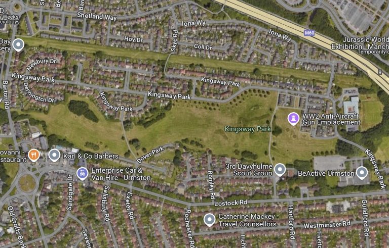
A walk around this park will take a good 30 minutes. It’s a safe place to walk dogs with the only real danger being access to Kingsway Park road in the top right corner of the map.
There’s no fence around the park so can be accessed from anywhere. I normally park at the BeActive car park, Dennington Drive or Dover Park.
There’s a culverted brook running under the park which may explain the lakes during the cold season just north of Dover Park. Keep south to avoid them.
There is an exit onto the very busy Barton Road which you can cross to access Broadway Park.
Kingsway Park
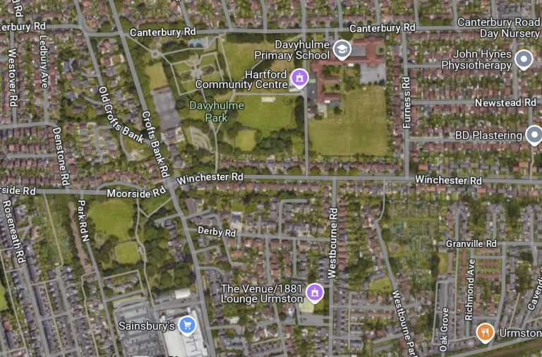
Park at Sainsbury’s or Hartford Community Centre.
Walking around Davyhulme Park takes 20 minutes and Golden Hill park, 10 minutes. I normally walk around both by crossing over at the junction of Winchester and Crofts Bank Roads.
You’re never far from a busy road on both of these parks so care should be taken. Be aware of the ponds on Davyhulme Park which play host to nesting moorhens and ducks.
Davyhulme and Goldenhill Parks
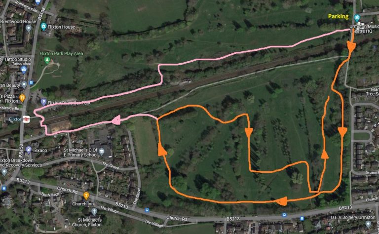
Park on Pennybridge Lane which is accessed from Flixton Road next to The Bird in the Hand pub.
Walking around this side of the golf course only takes 20 minutes so extend it by zig-zagging across the course.
Alternatively, join the public footpath alongside the railway as shown by the pink route. There is a stile on this footpath. You can cross the railway on the footbridge which has steps, or go to Flixton Road.
William Wroe, disused golf course
Park on Pennybridge Lane which is accessed from Flixton Road next to The Bird in the Hand pub or at Flixton Train Station (pay and display) or in the free car park opposite Rothiemay Road.
This is the more popular side of the disused golf course. There are plenty of routes.
A walk around the full perimeter will take 30 minutes or so.
Flixton Park and North side of William Wroe
Book Your Free Meet And Greet
07794576859
We are always open!
Our Service Area
Our pet care service area is centred on Urmston. Specifically the area bounded by the M60, River Mersey, Manchester Ship Canal and The Mile Road leading to Carrington.
If you are unsure whether we cover your area, just send us a quick message.
If you live outside the area we cover, we still may be able to help!